By Christopher Reynolds
Los Angeles Times
LOS ANGELES—That long, hot summer is nearing its end. Kids are back in school. This might be the moment to plot a California trip with more changing leaves and less traffic.
I’ve pulled together 13 fall travel ideas here, from deserts to coast with a couple of mountain destinations mixed in. Consider this a reminder that traveling around California is like painting a Navy ship: Once you think you’re done, you’re overdue to start again.
As evidence of this state’s perpetual change, at various points below you will find a Tin Town, a Tin City, a Hotel Wren, a Hidden Kitchen, a Fog Eater Cafe, a Skunk Train, and a Bear Gulch Cave. Only those last two existed in the 20th century.
Borrego Springs
Related Stories
This lonely San Diego County desert town, about 50 miles from the nearest Starbucks, deserves the attention of anyone who really wants peace and quiet. It’s home to perhaps 4,000 year-round residents, star-struck by night, startling at dawn, surrounded by the largest state park in California, Anza-Borrego Desert State Park.

A metal sculpture of a serpent by artist Richard Breceda. Luis Sinco/Los Angeles Times/TNS
Distance: A 4-hour drive from L.A. (154 miles from L.A. City Hall, via Google Maps).
 Palm Canyon Drive. (Christopher Reynolds/Los Angeles Times/TNS)
Cambria
The rest of the Cambria isn’t bad, either, including the shops and galleries along Main Street (which is deceptively long) and the piney slopes above.

The beach boardwalk along Moonstone Beach. Allen J. Schaben/Los Angeles Times/TNS
Distance: A 4-and-a-half hour drive from L.A. (237 miles).
Carmel
Carmel has become a jewel box of a town, with a main street, Ocean Avenue, that runs right down to the beach and sea. The architecture is full of storybook influences and curlicues. The prices—well, the prices are high. But with them come an intimate town setting.
Whether on foot, on a bike or in a car, you should take Ocean Avenue down to Scenic Road, turn left and keep on rolling until you’re overlooking Carmel River Scenic Beach. As fetching as the manmade landscape of Carmel can be (on the left side of that drive), the natural setting on the right is better.

A scenic road. Christopher Reynolds/Los Angeles Times/TNS
Distance:A 5-hours-and-45-minutes drive from L.A. (323 miles).
June Lake and the Eastern Sierra
Distance: A 5-and-a-half hour drive from L.A. (315 miles).
Joshua Tree and 29 Palms
Just about everyone, it seems, has realized the appeal of Joshua Tree (the national park and the town) in the last few years. As the weather cools, the park’s cartoonish boulders, outlandish flora and winding trails become more approachable (but don’t get too close to those jumping cholla cactuses). If you’re a newbie, don’t miss Hidden Valley, Cap Rock, or the Skull Rock Nature Trail.
There are also more assets farther east on California 62 in the town of 29 Palms, which has its own (much less-trafficked) park entrance, along with Tin Town, a compound that includes the tasty Kitchen in the Desert restaurant and several trendy shops.
Distance:Joshua Tree is 3-and-a-half hours’ drive (127 miles) from L.A.; 29 Palms, 3 hours and 45 minutes (142 miles).
La Jolla

Splashing waves near La Jolla Cove. Christopher Reynolds/Los Angeles Times/TNS
Distance: 2-and-a-half hours from L.A. (120 miles)
The Village of Mendocino

Passengers ride a rail bike through the redwoods of Mendocino County. Christopher Reynolds/Los Angeles Times/TNS
Distance:90-minute flight from LAX northwest to SFO, then a 4-hour drive; or 534 miles of straight driving.
Ojai
Whether the goal is a stroll among shops on Ojai Avenue or a hike in the Topatopa Mountains, the town of Ojai pulls in a lot of people on weekends, even in summer when it’s hot. Fall is mellower, even if the hills might be a little browner. In the heart of town, Libbey Park is always a draw for kids.

The newly renovated Hotel El Roblar. Christopher Reynolds/Los Angeles Times/TNS
Distance: About a 2-hour drive from L.A. (83 miles)
Pinnacles National Park
This strange realm of pointy peaks, rocky caves and soaring condors is California’s youngest and smallest national park, set in the underappreciated middle of California, where farms, ranches, and vineyards blanket the valleys and hills. In spring it’s crowded. In summer, it’s oppressively hot. So fall is a good bet. The High Peaks Trail, Condor Gulch Trail, and Bear Gulch Cave (on the east side of the park) are strenuous but popular for their commanding views and stony settings. There’s no road connecting the east and west sides of the park, so you’ll want to approach from the east if camping overnight. On the west side of the park, visitors head for the Balconies Cave.
Distance: About a 5-hour drive from L.A. (268 miles).
San Francisco
Distance: A 90-minute flight from LAX to SFO.
Paso Robles

The walk-through light experience at Sensorio. Francine Orr/Los Angeles Times/TNS
Check out:If you like the idea of parking once and wandering around, you’ll find about 25 more winery tasting-room options, a spacious beergarden patio at Barrelhouse Brewing Co., excellent meals at Etto Pasta Bar and sheep’s milk ice cream from Negranti Creamery, at Tin City, about 3 miles south of downtown Paso.
Distance: A 3 hour-and-45 minute drive from L.A. (206 miles).
Santa Barbara
Distance: A 2-and-a-half hour drive from L.A. (114 miles).
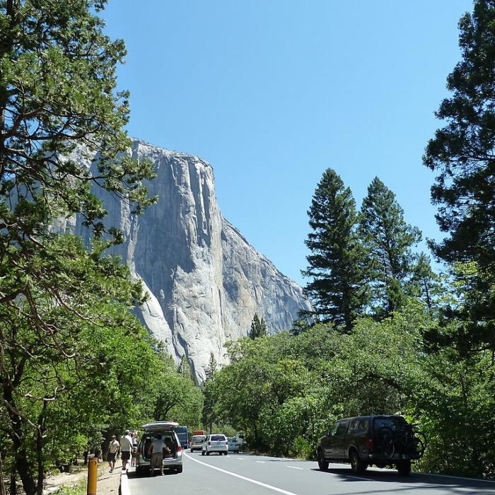
Yosemite National Park

Hikers walk on in the Valley. Eric Thayer/Los Angeles Times/TNS
Distance:A 5-hour drive to the park’s south entrance (280 miles), 6 hours to Yosemite Valley (312 miles).