
Bhulekh UP refers to the online land records portal for the state of Uttar Pradesh, India. It is an official platform managed by the Uttar Pradesh Revenue Department to provide citizens with easy access to land and property records. Here’s a detailed overview:
Key Features of Bhulekh UP
- View Land Records (Khasra/Khatauni)
 Go to the official website
 Khatauni (Rights Records / Real Time)
 Bhu-Naksha (Uttar Pradesh)
 Real Time Khatauni Dashboard

- Search Options
- Search by:
- Khasra Number
- Khata Number
- Owner’s Name
- Village/Town
- Search by:

- Download Records
- Obtain certified copies of land records (e.g., Jamabandi, Khatauni) for legal or personal use.
- Application for Mutation (Dakhil-Kharij)
- Request updates to land records after property transfer or inheritance.
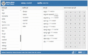
How to Access Bhulekh UP
- Visit the Official Website:
- bhulekh.up.gov.in (Available in Hindi).
- Select District, Tehsil, and Village:
- Navigate through the dropdown menus to locate your property.
- Enter Details:
- Input the Khasra/Khata number or owner’s name to view records.
- Download/Print:
- Save or print the records for future reference.
Required Documents
- Property details (Khasra/Khata number).
- Identity proof (Aadhaar, PAN, etc.) for mutation requests.
Important Notes
- Language: The portal is primarily in Hindi. Use browser translation tools if needed.
- Offline Help: Visit the nearest Tehsil Office or Lehkpal for assistance.
- Verification: Always cross-check records before legal transactions to avoid disputes.
Mobile App
- The UP government has launched the UP Bhulekh App for Android users to access records on the go.
Caution
- Beware of fraudulent websites. Only use the official portal (bhulekh.up.gov.in) for secure access.
For further queries, contact the UP Revenue Department Helpline or visit your local Tehsil office.
Bhunaksha UP refers to the geospatial mapping platform tailored for Uttar Pradesh (UP), India. It is part of the Bhunaksha suite developed by the National Informatics Centre (NIC) to provide digital land and property mapping services. Here’s a detailed overview:

1. What is Bhunaksha?
- A web-based GIS (Geographic Information System) tool for visualizing land records, cadastral maps, and property details.
- Used by citizens and government authorities for land management, dispute resolution, and urban planning.
- UP-specific portal: Focuses on districts and villages in Uttar Pradesh.
2. Key Features
- Cadastral Maps: View land parcels (Khasra, Khatauni numbers) with boundaries.
- Land Records: Check ownership details, plot size, and land use.
- Overlay Tools: Compare historical and current maps for changes.
- Measurement Tools: Calculate area, distance, etc.
- Integration: Linked to UP Land Record Portal (Bhulekh UP).
3. How to Access Bhunaksha UP
- Visit the Official Website:
- National NIC Portal: https://bhunaksha.nic.in
- Select Uttar Pradesh from the state dropdown.
- Search Options:
- Choose district → tehsil → village → enter Khasra/Khata number.
- View Maps:
- Interactive maps with zoom/pan options. Export maps as PDF/JPEG.
4. Required Information
- Khasra Number (land parcel ID) or Khatauni Number (owner’s account).
- Village and tehsil details.
5. Troubleshooting Tips
- Site Not Loading? Check NIC server status or try during non-peak hours.
- Outdated Data? Contact local revenue office (Lekhpal/Tehsildar) for updates.
- Mobile Access: Use a desktop for better compatibility.
6. Related Services
- Bhulekh UP (UP Land Records): https://upbhulekh.gov.in
- e-District UP: For property mutation, certificates, etc.
7. Need Help?
- Contact NIC Support: Email
support@nic.inor call your district’s NIC office. - Local Authorities: Visit the nearest Tehsil office or CSC (Common Service Centre).