
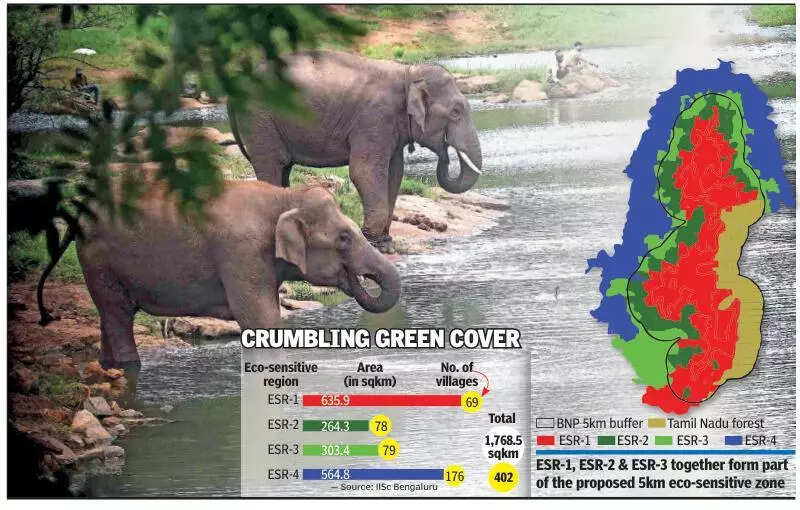
BENGALURU: Amid an intensifying legal and policy tussle over the extent of the eco-sensitive zone (ESZ) around Bannerghatta National Park (BNP) on the city’s outskirts, ecological scientists from the Indian Institute of Science (IISc) have recommended a 5km ESZ buffer covering 1,768.4sqkm and over 400 villages around the protected area.The proposal cites sustained forest degradation, rapid urbanisation, and irreversible ecological risks along the park’s periphery. The scientists have also called for strict regulation of activities across four categories of ecologically sensitive regions (ESRs) within the proposed ESZ.
The recommendations were based on a detailed assessment of land-use and land-cover changes, using temporal remote sensing data, ancillary information from govt agencies, and extensive field investigations conducted in 2015. The IISc team also simulated likely development patterns around BNP up to 2027. While the models indicated relatively minimal land-use changes within the core park area, they revealed alarming transformations in the buffer zones, largely driven by unplanned urban growth.
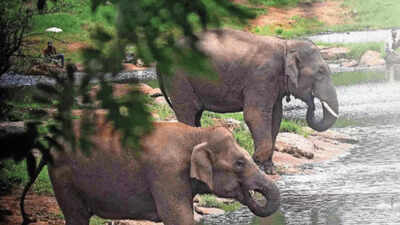
Prof TV Ramachandra, of IISc’s Centre for Ecological Sciences, said: “As per our study, the moist deciduous forest cover in the BNP landscape sharply declined from 50.4% in 1973 to a shocking 29.2% in 2015. Given the present rate of development, this is likely to reduce further because of anthropogenic pressures around BNP. Only in Ragihalli, Manjunatha, Yelavantha, and Bettahalli regions, where protection measures are stronger, disturbance is minimal.” The study also found that 87 of the 138 plant species recorded in BNP’s core and buffer areas were medicinally important, underlining the landscape’s ecological significance.Applying the same methodology used to assess the Western Ghats, the IISc team classified the BNP buffer into multiple ESR categories based on biological, geo-climatic, ecological, hydrological, environmental, and social attributes. “The ESR-1 regions require the highest level of conservation, with no further degradation permitted. About 635.9sqkm covering 69 villages fall under ESR-1,” Ramachandra explained.He added that ESR-2 zones comprise 78 villages across 264.3sqkm, and even minor unregulated activity in these areas could adversely impact ESR-1 regions. “Hence, stricter regulation and improvement of forest areas and surroundings through enhanced protection are essential,” he said, noting that ESR-1, ESR-2, and ESR-3 together form part of the proposed 5km ESZ.The study has recommended a complete ban on quarrying and mining in ESR-1 and ESR-2 regions, with no new licences for sand mining or quarrying. “Permitted and regulated activities include agriculture, organic farming, animal husbandry, greenhouses, agro-processing industries, IT parks, extraction of medicinal plants, forest improvement through village forest committees, and collection of non-timber forest produce,” Ramachandra added.Highlighting BNP’s ecological importance, the scientists noted that the park lies at the confluence of the Western and Eastern Ghats, and is among the oldest habitats of Asian elephants. “Bannerghatta supports around 200 resident elephants and nearly 350 migratory elephants from Cauvery Wildlife Sanctuary and neighbouring Tamil Nadu,” the study noted.