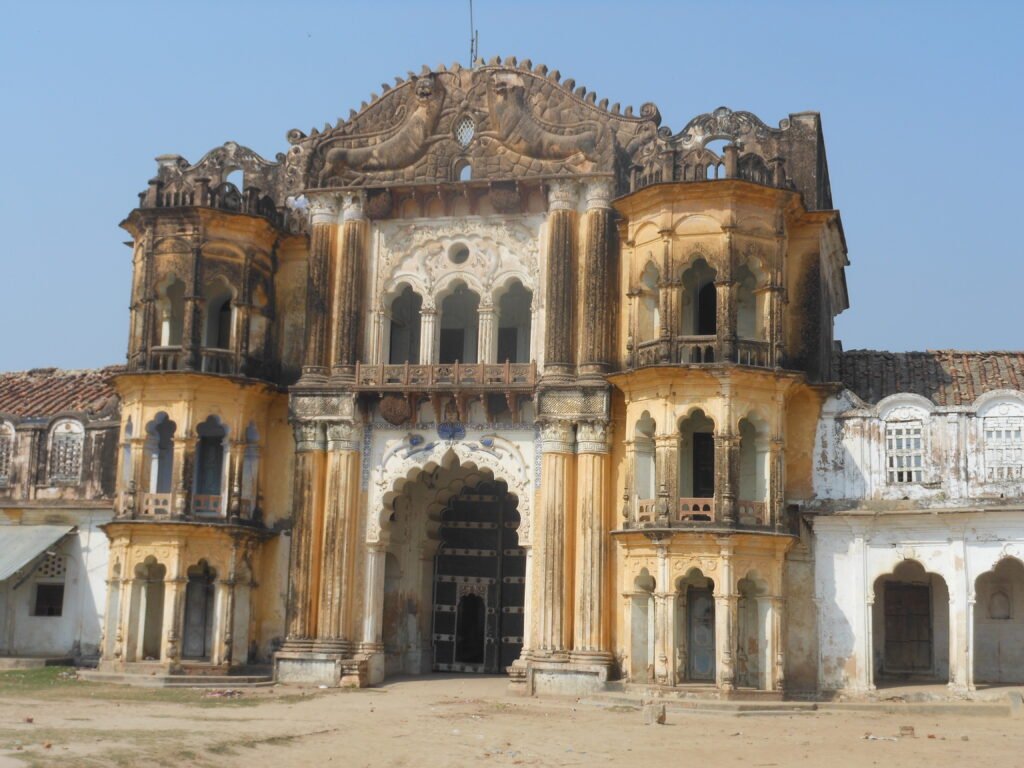
Ambedkar Nagar, a district in the Awadh region of Uttar Pradesh, is a land steeped in history, spirituality, and modern political significance. Carved out from the erstwhile Faizabad district (now Ayodhya) on September 29, 1995, this region is not just a modern administrative entity but a tapestry woven with threads of ancient mythology, medieval empires, and contemporary social reform.
The district is named after Dr. Bhim Rao Ambedkar, the chief architect of the Indian Constitution and a tireless crusader for the rights of the depressed classes. This naming was a monumental step by the then Chief Minister Mayawati to honor his legacy in a region that has seen the rise and fall of empires, the confluence of holy rivers, and the birth of notable freedom fighters.
In this comprehensive blog, we will navigate through the rich history of Ambedkar Nagar. We will explore its mythological connections to the Ramayana, its transformation during the Mughal era under Emperor Akbar, its growth under the British Raj, and its journey to becoming a district in the 21st century. We will also delve into its geographical significance, demographic shifts, and economic landscape.
Chapter 1: The Geographical Canvas of Ambedkar Nagar
Before we dive into the historical timeline, it is essential to understand the geography of Ambedkar Nagar, as it has played a pivotal role in shaping its history and culture.
1.1 Location and Topography
Ambedkar Nagar is situated in the north-eastern part of Uttar Pradesh, forming a part of the central Ganga basin. It lies between 26° 09′ N to 26° 40′ N latitudes and 82° 12′ E to 83° 05′ E longitudes.
-
Borders: The district is bounded by the Basti and Sant Kabir Nagar districts to the north, Gorakhpur to the north-east, Sultanpur to the south, Ayodhya to the west, and Azamgarh to the east. This strategic location has historically made it a connecting point between various cultural and economic zones of Uttar Pradesh .
-
Area: The total area of the district is approximately 2,350 sq km. The total length from east to west is about 75 km, while the breadth from north to south is roughly 42 km .
1.2 The Lifelines: Rivers and Water Bodies
The geography of Ambedkar Nagar is defined by its rivers, which have not only provided irrigation but also hold deep spiritual significance.
-
The Sarayu River: The Sarayu is the main river, forming the northern boundary of the district. It is famously associated with the epic Ramayana, providing a spiritual aura to the blocks of Tanda, Rajesultanpur, Ramnagar, and Baskhari which lie along its course .
-
The River Tons (Tamsa): The district headquarters, Akbarpur, is situated on the banks of the Tons River (locally known as Tamsa). This river famously divides the city into two parts: Akbarpur and Shahzadpur, with the latter being the main commercial center. The confluence of the Tamsa and Biswi rivers is considered highly sacred and is known as Shravan Kshetra Dham .
-
Lakes and Tals: Apart from rivers, the district has several lakes that are crucial for irrigation, such as Devhat Lake, Rajesultanpur Lake, Hanswar Lake, and Darvan Lake. The region is also dotted with numerous ponds (tals) which are remnants of the shifting courses of the Ghaghra river system, indicating a rich and dynamic geographical history .
1.3 Climate of the Region
The climate of Ambedkar Nagar is typical of eastern Uttar Pradesh, characterized by three distinct seasons:
-
Cold Weather Season (November to February): Winters are cold with temperatures dropping to around 9°C.
-
Hot Weather Season (March to mid-June): Summers are sweltering.
-
Season of Rains (mid-June to October): The southwest monsoon brings significant rainfall, crucial for the region’s agriculture which relies heavily on these seasonal cycles .
Chapter 2: The Mythological and Ancient Roots
The history of Ambedkar Nagar is deeply intertwined with Hindu mythology, particularly the Ramayana. The land has been mentioned in ancient texts and is believed to be a place of penance and meditation for sages.
2.1 The Legend of Shravan Kshetra
One of the most significant mythological events associated with this region is the story of Shravan Kumar. According to the Ramayana, it is near the confluence of the Tamsa and Biswi rivers that King Dasharatha of Ayodhya accidentally shot the young boy Shravan Kumar with an arrow. The king was hunting and mistook the sound of Shravan filling water for a deer. This tragic event is a pivotal point in the Ramayana, as it led to the curse that caused King Dasharatha to die of separation from his son, Rama .
-
Shravan Kshetra Dham: Today, the site is a prominent pilgrimage spot known as Shravan Kshetra Dham. It serves as a reminder of the region’s connection to the epic narrative and has been a place of reverence for centuries .
2.2 The Influence of Awadh and Sages
Historians and local traditions suggest that the area was a hub of spiritual activity. The rivers Sarayu, Ghaghra, and Tamsa provided a serene environment for sages to perform meditation and rituals. The land is believed to have witnessed the presence of great rishis who contributed to the spiritual and cultural fabric of ancient India. This area was part of the larger Kosala kingdom, of which Ayodhya was the capital. It is believed that Lord Rama’s son, Kusha, ruled in this extended region .
Chapter 3: The Medieval Period and Mughal Influence
The medieval history of the region is largely defined by the arrival of the Mughals, particularly under the reign of Emperor Akbar. It was during this period that the city of Akbarpur was established and the modern foundations of the district were laid.
3.1 The Arrival of Emperor Akbar in 1566 AD
The most significant turning point in the region’s medieval history came in 1566 AD when the Mughal Emperor Akbar visited the area.
-
The Foundation of Akbarpur: Legend has it that Akbar camped at a location that is now known as Tehsil Tiraha. Impressed by the strategic location, he decided to establish a settlement.
-
Historical Monuments: To commemorate his stay, he built a mosque near the Tehsil Tiraha, which is known today as the Qila Masjid or Fortress Mosque. He also established a settlement which he named Akbarpur [citation:official history].
3.2 The Shahi Bridge and Shahzadpur
One of the major challenges faced by the emperor was crossing the River Tamsa. To solve this, he commissioned the construction of a wooden bridge, known at the time as the Shahi Bridge.
-
The Connection: This bridge connected the two sides of the river, linking what would later become Akbarpur and Shahzadpur.
-
The Legacy: While the original wooden bridge is long gone, it has been replaced by a modern structure. However, the names remain. Shahzadpur was populated by Akbar’s descendants or nobles who migrated to the region, and it continues to be the main commercial center of the city today [citation:official history].
3.3 The Rajput and Rajbhar Rule
Before the Mughals consolidated their power, the region saw rule by local chieftains.
-
The Rajbhar Dynasty: Around 1300 AD, the Rajbhars had a strong presence around the Jalalpur area, which is now an important tehsil in the district.
-
The Princely States: Two significant princely states existed: Bhiti and Surahpur. Historical accounts suggest that Surahpur was conquered by Syed Salar Masoud Ghazi (also known as Ghazi Mian), a legendary figure in the region, while the Bhiti princely state was taken over by Rajputs.
-
Settlement of Nakipur: During this time, an Iranian Sardar named Naki settled in the area, establishing a village that is now famous as Nakipur or the city of Nagpur [citation:official history].
Chapter 4: The British Era and the Path to Modernity
The advent of the British East India Company brought about administrative and infrastructural changes that shaped the region’s modern character. While much of the area remained under the influence of the princely states of Awadh, British rule introduced new systems.
4.1 The Nawabs and British Supremacy
During the Nawabi period, the region began to be recognized for its strategic and economic significance. However, as the British Empire expanded, they took control of Awadh.
-
Infrastructure Development: The British, known for their administrative and engineering prowess, established schools, hospitals, bridges, and a network of roads and railways. They formalized the administrative divisions like tehsils and blocks.
-
Social and Political Awakening: The late 19th and early 20th centuries saw the rise of the Indian freedom movement. The echoes of this movement were felt in Ambedkar Nagar, which was part of the Faizabad district.
4.2 The Freedom Struggle and Local Leaders
The region contributed significantly to India’s struggle for independence. Notably, Akbarpur is the birthplace of Ram Manohar Lohia (1910-1967), a prominent freedom fighter and socialist leader.
-
Ram Manohar Lohia: Lohia was a key figure in the Indian National Congress and later founded the Socialist Party. His legacy is deeply ingrained in the political consciousness of Ambedkar Nagar. He worked tirelessly against colonial rule and advocated for the rights of the downtrodden .
-
Other Leaders: Freedom fighters like Jai Ram Varma and Dr. Ganesh Krishna Jaitley also emerged from this region, contributing to the independence movement and the subsequent political landscape of the country .
Chapter 5: The Birth of Ambedkar Nagar District (1995)
The creation of Ambedkar Nagar district is a crucial chapter in the history of the region. It was a landmark decision that gave identity to this historical land and was a tribute to a monumental figure of the 20th century.
5.1 The Demand for a Separate District
For years, the region was a part of the Faizabad district. However, the residents of the Akbarpur and Tanda regions felt that their administrative needs were not being met due to the vastness of the Faizabad district. There were repeated demands for a separate administrative unit.
5.2 The Announcement by Mayawati
September 29, 1995 marks a red-letter day in the history of the region. The then Chief Minister of Uttar Pradesh, Mayawati, announced the creation of a new district carved out of Faizabad.
-
Establishment: The district was formally established on September 29, 1995.
-
Naming: It was named Ambedkar Nagar in honor of Dr. Bhim Rao Ambedkar. This was a significant political and social statement, as Mayawati’s government sought to honor the leader who fought for the rights of the “depressed classes” and “weaker sections of society” .
-
Headquarters: Akbarpur, with its rich history dating back to the Mughal era, was made the district headquarters .
5.3 Administrative Evolution and Tehsil Formation
The formation of the district was just the beginning. The administration had to be structured from the ground up.
-
Initial Structure: Initially, the area was divided into the tehsils of Akbarpur and Tanda.
-
Creation of Jalalpur: On June 22, 1989, even before the district was formed, Jalalpur was carved out of Akbarpur tehsil based on local demands.
-
Formation of Other Tehsils: After the district’s creation, Tanda and Alapur were formally constituted as tehsils (with Tanda being officially embodied on January 1, 1996, and Alapur shortly after).
-
Latest Addition: On October 31, 2007, Bhiti was created as the fifth tehsil, carved out of parts of Akbarpur tehsil [citation:official history].
Today, Ambedkar Nagar comprises five tehsils (Akbarpur, Tanda, Jalalpur, Alapur, Bhiti), ten blocks, 1,757 revenue villages, and 930 gram panchayats [citation:official history].
Chapter 6: Demographic and Social History
Understanding the population and social composition of Ambedkar Nagar is key to understanding its modern history and the dynamics that have shaped it since independence.
6.1 Population Growth (1901–2011)
The population of the region has grown steadily over the last century, reflecting the general demographic trends of Uttar Pradesh.
-
Total Population (2011): According to the 2011 census, the district has a population of 2,397,888.
-
Decadal Growth: The population growth rate from 2001 to 2011 was 18.35%. The population density is relatively high, standing at 1,021 inhabitants per square kilometer .
-
Urban vs. Rural: Only 11.71% of the population lives in urban areas, indicating the predominantly agrarian nature of the district.
6.2 Religion and Language
-
Religion:
-
Hinduism is the majority religion, with approximately 82.81% of the population adhering to it.
-
Islam is the second-largest religion, making up 16.75% of the population.
-
Other religions like Christianity (0.11%), Buddhism (0.08%), Sikhism (0.04%), and Jainism (0.01%) have smaller but significant presences .
-
-
Languages:
-
Hindi is the official language and the most widely spoken tongue, with nearly 80% of the population speaking it.
-
Awadhi, a dialect of Hindi, is spoken by over 10% of the population, reflecting the region’s cultural roots in the Awadh region.
-
Urdu and Bhojpuri are also spoken by significant minorities in the district .
-
Chapter 7: Economic History and Present-Day Industry
The economy of Ambedkar Nagar has traditionally been agro-based, but it has seen significant industrial development in recent decades.
7.1 The Textile Hub: “Tanda Terrycot”
The town of Tanda is particularly famous for its textile industry. It is known throughout India for its high-quality “Tanda Terrycot” fabric. The power loom industry in Tanda and the surrounding areas is a major employer and is a significant contributor to the district’s economy. The history of textile weaving in Tanda is several decades old, with the town evolving from a small-scale weaving center to a major producer of synthetic fabrics .
7.2 Industrial Growth
Several key industries have been established in the district, driving economic growth.
-
NTPC Tanda Thermal Power Plant: Located in the Makhdoom Nagar area near Tanda, this thermal power plant is a major source of energy for the region. It is owned and operated by the National Thermal Power Corporation (NTPC) and provides employment to a large number of people .
-
Jaypee Group Cement Plant: The Jaypee Group has set up a cement manufacturing plant at Naseebjot Village near Tanda. This plant, known as Jaypee Ayodhya Grinding Operations (JAAGO), is a significant industrial unit that has boosted the local economy .
-
Akbarpur Sugar Mill: Situated near Mijhaura, about ten kilometers from Akbarpur, this sugar mill is an important agro-based industry that processes sugarcane grown in the surrounding villages .
7.3 Backward Regions Grant Fund (BRGF)
Despite its industrial growth, Ambedkar Nagar faced significant developmental challenges. In 2006, the Ministry of Panchayati Raj identified it as one of the 250 most backward districts in the country. Consequently, it has been receiving funds from the Backward Regions Grant Fund Programme (BRGF) to address infrastructure and development gaps .
Chapter 8: Heritage and Tourism
Ambedkar Nagar is not just an administrative and industrial hub; it is also a center of spiritual tourism and cultural heritage.
8.1 Shravan Kshetra Dham
As previously mentioned, this is the most significant pilgrimage site in the district. Located at the confluence of the Tamsa and Biswi rivers, it attracts devotees from all over the country. The site is dedicated to the memory of Shravan Kumar and is considered sacred .
8.2 Kichhauchha Sharif
This town, located in the district, is a major center of Sufi culture. It is home to the shrine of Ashraf Jahangir Semnani, a 14th-century Sufi saint. The shrine, also known as Kichhauchha Sharif, is a place of pilgrimage for people of all faiths. The town has a rich history of Sufi scholarship and is known for its syncretic culture, where Hindu and Muslim traditions blend seamlessly. Notable poets and scholars like Syed Waheed Ashraf and Syed Amin Ashraf hail from this town .
8.3 Places of Historical Interest
-
Qila Masjid (Fortress Mosque): Built by Emperor Akbar in 1566 AD, this mosque in Akbarpur is a testament to the Mughal influence in the region.
-
Shahi Bridge: While the original is gone, the modern bridge at the same spot is a historical landmark that connects the two parts of Akbarpur.
-
The Birthplace of Ram Manohar Lohia: Akbarpur is the birthplace of the eminent freedom fighter and socialist leader. His legacy is preserved and celebrated in the city.
Chapter 9: Notable Personalities
Ambedkar Nagar has produced several distinguished personalities who have made significant contributions to Indian politics, literature, spirituality, and sports.
-
Ram Manohar Lohia (1910-1967): An iconic freedom fighter and socialist leader, born in Akbarpur .
-
Bashir Badr: A renowned Urdu poet, especially famous for his ghazals .
-
Anwar Jalalpuri (1947-2018): An Urdu poet from Jalalpur who is famous for translating the Bhagavad Gita from Sanskrit to Urdu .
-
Arunima Sinha: The first Indian woman amputee to climb Mount Everest. She hails from the district and her achievement is a source of inspiration .
-
Hashmi Miya (Syed Mohammed Hashmi Ashrafi Al Jilani): A prominent Muslim scholar and Sufi from the region .
-
Political Leaders: The district has given several political leaders to the state and country, including Hari Om Pandey, Rakesh Pandey, Ritesh Pandey, Lalji Verma, and Masood Ahmad, among others .
Chapter 10: The Future of Ambedkar Nagar
As of the 2026 calendar date, Ambedkar Nagar stands at a crossroads of history and modernity. With the construction of the Purvanchal Expressway and the Gorakhpur Link Expressway passing through or near the district, connectivity has improved significantly .
The district is poised for further growth in its industrial sector, particularly in cement, textiles, and power generation. The agricultural sector is also being modernized. However, the district still faces the challenge of ensuring balanced development across all its blocks and villages, a task that the local administration and the state government are continuously working on.
Conclusion
The history of Ambedkar Nagar is a fascinating journey from the ancient banks of the Sarayu and Tamsa rivers to the modern administrative corridors of Akbarpur. It is a land of legends where the epic of Ramayana plays out, where Mughal emperors established their monuments, and where the struggle for Indian independence found its heroes.
The creation of the district in 1995 was a monumental event that honored the legacy of Dr. B.R. Ambedkar and gave a distinct identity to this culturally rich region. Today, Ambedkar Nagar stands as a testament to India’s diversity, seamlessly blending its ancient spiritual past with the vibrancy of modern industry and agriculture. It remains a district of great significance in the Awadh region, continuing to write its history with each passing day.
External Links:
Note: This blog post aims to provide a comprehensive historical overview of Ambedkar Nagar district. The information has been sourced from government records, historical texts, and reputable encyclopedic sources.