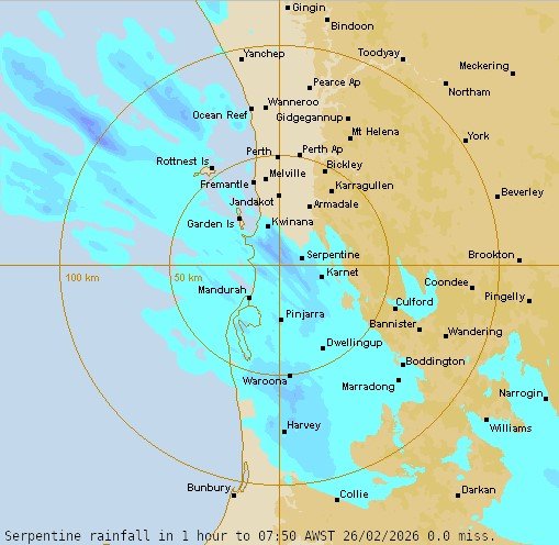
Perth has woken to thunder, lightning and significant rain for the first time in 2026.
Despite the winter-like conditions on Thursday morning, the thunderstorms are expected to ease.
The Bureau of Meteorology forecasts a top of 29C on Thursday with partly cloudy skies and a slight chance of showers, most likely in the morning.
Early hourly forecasts show temperatures across Perth will climb steadily through the day, with conditions expected to remain cloudy.
South-easterly winds will shift south-westerly by midday at 15km/h to 25km/ before easing in the evening and bringing a cool breeze to locals.
South-easterly winds hit Perth in the morning and BoM expects it to shift south-westerly in the afternoon.
In contrast, a heatwave warning has been issued by the BoM for parts of Western Australia.

Severe heatwave conditions will peak over the coming days for south coastal areas locations including Jerramungup and Ravensthrope.
Maximum temperatures in the mid to high 30s over inland areas, tending to the high 20s to low 30s over coastal locations.
Overnight minimum temperatures in the mid to high teens, peaking Thursday morning in the low twenties.
The heat will continue in Perth on Friday and seabreezes will hit coastal suburbs late in the day on Saturday.
Across the State, residents in the Kimberley, Pilbara, Gascoyne and North Interior will endure heatwave conditions, with temperatures soaring into the 40s.
Harsh heat will hit those areas over the weekend and continue to creep up to the mid 40s by the start of next week.
BoM says UV levels will be extreme, warning Perth locals to take sun safety seriously and advising residents to close their windows to keep heat out of the home.
PERTH WEATHER FORECAST
Thursday: Sunny, 21-30 ☀️
Friday: Sunny 18-26C ☀️
Saturday: Sunny 12-25C 🌤️
Sunday: 12-25C☀️
Monday: Sunny, 14-30C☀️
Tuesday: Sunny, 17-32C☀️
Wednesday: Sunny, -17 33C☀️