

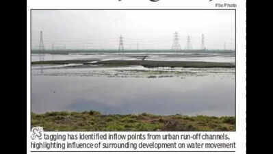
Gurgaon: Disrupted drainage connectivity, encroachment pressures and the presence of globally threatened raptor species across the transboundary wetland spanning Haryana and Delhi — Najafgarh jheel is under ecological stress. The findings are part of a preliminary scientific assessment of Najafgarh jheel by a two-member team from National Centre for Sustainable Coastal Management (NCSCM). The exercise involved GPS-based ground mapping, visual documentation and qualitative assessment of land use and biodiversity to delineate the wetland’s hydrological and ecological boundaries. The findings emerged from a two-day reconnaissance survey conducted on Nov 19 and 20, 2025, by the NCSCM team, comprising Dr Subbareddy Bonthu and Dr Hariharan G, along with officials from Delhi’s irrigation and flood control department and Haryana’s GMDA. The matter pertaining to Najafgarh jheel is being heard by National Green Tribunal (NGT). The case arises from an application filed by Indian National Trust for Art and Cultural Heritage (INTACH) seeking protection and restoration of Najafgarh Jheel. The survey comes after NGT sought a report from the govt after INTACH sought compliance with the tribunal’s Feb 2017 order to “designate Najafgarh Jheel as a wetland”. “The assessment recorded structural disruptions in natural drainage. While Leg-2 (Badshapur drain) showed near-complete connectivity with the Najafgarh Drain, Leg-1 and Leg-3 were incomplete, resulting in disrupted conveyance and altered wetland hydrodynamics. GPS tagging identified multiple inflow points from urban run-off channels, while spatial observations revealed heterogeneous land-use patterns, including residential and industrial development, agriculture and flood-control structures, leading to discernible encroachment pressures,” the survey stated.“GPS tagging identified multiple inflow points, particularly from urban run-off channels, highlighting the influence of surrounding development on water movement into the wetland. Spatial observations further revealed heterogeneous land-use patterns, including residential and industrial development, agriculture and flood-control structures, with cumulative anthropogenic pressures leading to discernible encroachment and hydrological modification,” it stated.On biodiversity, the survey confirmed the presence of globally threatened raptors, including the Steppe Eagle (Aquila nipalensis), Greater Spotted Eagle (Clanga clanga) and Imperial Eagle (Aquila heliaca), reinforcing Najafgarh Jheel’s role along the Central Asian Flyway as a key staging, roosting and wintering habitat. Meanwhile, NGT on Jan 19 granted the Union ministry of environment, forest and climate change (MoEF&CC) time until March 2026 to submit the final boundary delineation and ecological assessment. MoEF&CC informed the NGT that interim reports prepared earlier by (Wetlands International South Asia) WISA and World Wide Fund for Nature (WWF) India are being revalidated by NCSCM. The order was passed by a bench headed by NGT chairperson Justice Prakash Shrivastava, along with expert member Dr A Senthil Vel. The matter will next be heard on April 8, 2026.In an additional affidavit dated Nov 26, 2025, the ministry said a preliminary scientific assessment was received from NCSCM on Nov 25, 2015 following the field survey. During the hearing, MoEF&CC counsel sought time to clarify whether the annexed document reflected only field observations or constituted NCSCM’s preliminary report, adding that the final scientific assessment would be completed by March 2026. The tribunal also directed the ministry to place WISA and WWF India reports on record, subject to there being no objection. NCSCM told the tribunal that verification of the 210-metre hydrological contour would require field campaigns during Feb 2026, when water levels are expected to recede and sought time until March 15, 2026 to submit the definitive boundary delineation report. According to the preliminary report, the wetland’s predominant inundation footprint aligned with elevation contours between 209 and 211 metres above mean sea level, with 210 metres AMSL identified as the indicative hydromorphic boundary, pending confirmation during the dry season. Against these backdrops, Haryana proposed a large-scale engineering intervention to divert Gurgaon’s stormwater towards the Yamuna, involving intercepting channels, pumping against gradient and routing flows through outfall drain No 8 along KMP Expressway. The state pegged the project cost at around Rs 2,000 crore, arguing it would mitigate urban flooding in Gurgaon. However, INTACH’s Manu Bhatnagar questioned both the financial logic and technical viability of the proposal, saying the projected investment would be utilised for barely 10 days in a year during peak monsoon, remaining dry for the rest of the time. “Is such expenditure justified when Najafgarh Jheel itself can hold the entire floodwaters without any additional cost?” he said, adding that Gurgaon’s internal drainage remains inadequate and clogged. “